Entrée Resources Provides JV Licenses Update and Drill and Regional Exploration Results
VANCOUVER, British Columbia, April 09, 2026 (GLOBE NEWSWIRE) -- Entrée Resources Ltd. (TSX:ETG; OTCQB:ERLFF – the “Company” or “Entrée”) provides an update on matters related to the Entrée/Oyu Tolgoi joint venture (the “Entrée/Oyu Tolgoi JV”) mining licenses as well as drill and regional exploration results received from the Company’s joint venture partner Oyu Tolgoi LLC (“OT LLC”).
ENTRÉE/OYU TOLGOI JV LICENSES UPDATE
The Company continues to focus its efforts on the transfer of the Shivee Tolgoi and Javkhlant mining licenses (the “JV Licenses”) from the Company’s Mongolian subsidiary Entrée LLC to OT LLC. Transfer of the JV Licenses is necessary to enable Lift 1 Panel 1 underground development work on the Shivee Tolgoi mining license area to proceed.
On March 25, 2026, the Company delivered a non-binding proposal to the Minister of Industry and Mineral Resources of Mongolia as head of the Government Working Group established to negotiate the State’s interest in the area of the JV Licenses. The proposal contemplates, among other things, the transfer of the JV Licenses to OT LLC as required under the Oyu Tolgoi Investment Agreement and the Entrée/Oyu Tolgoi JV Agreement and payment of a negotiated royalty on the gross sales value of the Company’s concentrate as contemplated under the Minerals Law of Mongolia in lieu of the State being a 34% equity participant. The proposal is intended to form the basis for further discussions and negotiations with the Government of Mongolia.
On March 31, 2026, following the resignation of Prime Minister Zandanshatar, N. Uchral was sworn in as the 35th Prime Minster of Mongolia. On April 3, 2026, Prime Minister Uchral introduced his new cabinet, reappointing G. Damdinnyam as the Minister of Industry and Mineral Resources. The Company will continue to monitor the situation, including any potential changes to the Government Working Group, and provide further updates as considered necessary.
Entrée remains committed to working with the Government of Mongolia, Rio Tinto, and OT LLC in accordance with applicable laws of Mongolia to unlock the Oyu Tolgoi project’s full potential for the benefit of all parties.
DRILL AND REGIONAL EXPLORATION RESULTS
The Company is pleased to provide analytical results for one surface diamond drill hole (“DDH”) and 4 underground DDHs, which were part of the 2024 and 2025 in-fill drilling programs at the Hugo North Extension (“HNE”) deposit on the Entrée/Oyu Tolgoi joint venture property (the “Entrée/Oyu Tolgoi JV Property”) in Mongolia. Regional exploration results are also provided, including analytical results for nine DDHs from the 2025 regional drilling campaign testing several targets on the Shivee Tolgoi and Javkhlant mining licences. All work was completed by the Company’s joint venture partner OT LLC, with expenditures borne by OT LLC and Entrée in proportion to their participating interests in the Entrée/Oyu Tolgoi JV.
DRILL HOLE HIGHLIGHTS
Significant HNE Underground Drill Holes
- UGD951: 124 metres grading 3.41% copper equivalent (“CuEq”), including 62 metres grading 4.36% CuEq.
-
UGD952A: 42.4 metres grading 1.32% CuEq.
Significant Regional Exploration Drill Holes (Ulaan Khud Target)
- EGD198: 308 metres grading 0.29% copper, 107 ppm molybdenum, including 50.75 metres grading 0.47% copper, 118 ppm molybdenum.
-
EGD199: 420 metres grading 0.30% copper, 139 ppm molybdenum, including 150.46 metres grading 0.44% copper, 295 ppm molybdenum.
Note: CuEq for HNE is defined in Note 3 to Tables 1 and 2 below, where details on the drill hole assay intervals are also found.
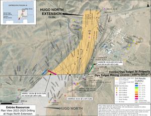
HNE DRILLING RESULTS
The new drill hole analytical results received from OT LLC include one underground DDH from the 2024 drilling program and one surface DDH and 3 underground DDHs from the 2025 drilling program on the HNE deposit. The surface DDH was collared on the Entrée/Oyu Tolgoi JV Property, and the underground DDHs were all collared from existing infrastructure on the Oyu Tolgoi mining licence (100% OT LLC) and drilled towards the northwest or northeast onto the Entrée/Oyu Tolgoi JV Property. The DDHs targeted mineralization within or surrounding the existing footprint of the HNE deposit (Figure 1) in the proposed Lift 2 block cave. Details about the 2024 drilling program, including DDH locations, were previously disclosed by Entrée on February 27, 2025 (see the news release titled, “Entrée Announces Drill Results From Hugo North Extension and Heruga Deposits”).
Analytical results from the surface and underground DDH data provided by OT LLC are summarized in Table 1 and Table 2, respectively, and are shown on Figure 1.
Collar and drilling information for 5 DDHs which were part of the 2024 drilling program but completed in 2025 (3 surface drill holes and 2 underground drill holes), as well as details for 28 DDHs from the approved 2025 drilling program (6 surface drill holes and 22 underground drill holes) are provided in Table 3 and Table 4 below.
Analytical results for 3 surface DDHs and 4 underground DDHs from the 2024 drilling program and 19 underground DDHs from the 2025 drilling program at HNE are still pending. These results will be reported as they become available from OT LLC.
Table 1: Surface Drill Results from the 2025 Drilling Program at the HNE Deposit1
| Drill Hole |
Year |
From (m) |
To (m) |
Length2 (m) |
Copper (%) |
Gold (ppm) |
Silver (ppm) |
CuEq3 (%) |
| EGD191 | 2025 | No | significant | results |
Note: EGD191 was terminated prior to reaching the HNE grade shell.
Table 2: Underground Drill Results from the 2024 and 2025 Drilling Programs at the HNE Deposit1
| Drill Hole | Year | From (m) |
To (m) |
Length2 (m) |
Copper (%) |
Gold (ppm) |
Silver (ppm) |
CuEq3 (%) |
| UGD927B | 2024 | 334 | 348 | 14 | 0.48 | 0.05 | 0.82 | 0.51 |
| and | 370 | 563.3 | 193.3 | 0.42 | 0.04 | 0.88 | 0.45 | |
| UGD951 | 2025 | 218 | 342 | 124 | 2.91 | 0.84 | 7.35 | 3.41 |
| including | 218 | 280 | 62 | 3.77 | 0.98 | 9.17 | 4.36 | |
| UGD952A | 2025 | 220 | 262.4 | 42.4 | 1.15 | 0.28 | 2.96 | 1.32 |
| UGD987 | 2025 | No | significant | results |
Notes for Tables 1 and 2:
- Analytical results are length weighted averages, only for the portions of the drill holes on the Entrée/Oyu Tolgoi JV Property.
- Lengths reported are drilled lengths. Approximate true widths are variable depending on the orientation of the drill hole. Several of the holes are geotechnical holes drilled subparallel to the trend of the porphyry. Other holes are drilled across the trend of the porphyry at varying orientations with estimated true widths ranging between approximately 20% and 70% of the drilled lengths.
- CuEq at HNE is calculated using the formula in the Company’s Technical Report on the Entrée/Oyu Tolgoi Joint Venture Project with an effective date of October 8, 2021, as follows: CuEq = Cu + ((Au * 35.7175) + (Ag * 0.5773)) / 67.9023, taking into account differentials between metallurgical performance and price for copper, gold and silver. Metal prices used are US$3.08/lb copper, US$1,292.00/oz gold, and US$19.00/oz silver. Metallurgical recoveries used are 82% for copper, 73% for gold and 78% for silver.
Figure 1: Plan View of Newly Released Assay Intervals and Locations of 2022-2025 Drill Holes

Surface drill hole EGD191 was collared above the centre of the surface projection of the HNE mineralized footprint and drilled very steeply towards the north. After crossing through approximately 1,078 metres of barren granodiorite, sedimentary and volcanic units, the final 29 metres intersected weakly mineralized volcanics averaging 0.23% copper, near the top of the porphyry deposit, at which point the DDH was terminated.
Underground DDH UGD927B was drilled at a moderate dip towards the northeast, parallel to the trend of the porphyry deposit. The DDH remained in low grade copper mineralization east of the main mineralized porphyry and was drilled primarily for geotechnical purposes.
Underground DDH UGD951 was collared on the Oyu Tolgoi mining licence and drilled at a gentle dip towards the west-northwest. After crossing onto the Entrée/Oyu Tolgoi JV Property at 218 metres it immediately entered into the western portion of the HNE deposit in heavily phyllic and potassic altered quartz monzodiorite, cut by occasional intervals of unmineralized biotite-granodiorite dikes (generally less than 10 metres in drilled width). The quartz monzodiorite is mineralized with significant amounts of chalcopyrite and bornite, along with minor pyrite and returned high grades of copper and gold as shown in Table 2. The last 7 metres of the drill hole crossed into the footwall of the deposit where copper and gold grades drop off significantly.
Underground DDH UGD952A was collared from the same drill pad as UGD951 but drilled at a moderate dip towards the northwest. The drill hole crossed through phyllic altered quartz monzodiorite cut by occasional biotite-granodiorite dikes, and is mineralized with moderate amounts of chalcopyrite, bornite and pyrite. The drill hole returned significant values of copper and gold as shown in Table 2 and was terminated in strong mineralization at a depth of 262.4 metres.
The final underground drill hole with analytical results is UGD987, which was collared from an underground drill pad on the Oyu Tolgoi mining licence, west of the HNE deposit. The drill hole was drilled northeast at a moderate dip, remaining parallel to, and west of the edge of the HNE deposit and was designed primarily for geotechnical purposes. The drill hole crossed a mix of lightly potassic and feldspar altered quartz monzodiorite, biotite-granodiorite and hornblende-biotite granodiorite. Analytical results between 480 and 558 metres were anomalous, averaging 0.30% CuEq over 78 metres. Beyond this the analytical results are insignificant to the end of the hole at 600 metres.
Table 3: HNE Surface Drill Hole Collar Details
| Drill Hole |
UTM East1 |
UTM North1 |
Elevation (masl) |
Length (m) |
Azimuth (degrees) |
Dip (degrees) |
Assay Status |
| EGD179 | 652105 | 4768420 | 1197 | 1689.8 | 353 | -86.8 | Not assayed |
| EGD179A | 652105 | 4768420 | 1197 | 343.8 | 351 | -86.4 | Not assayed |
| EGD186 | 652373 | 4768555 | 1175.384 | 1012.4 | 352 | -86.5 | Not assayed |
| EGD186A | 652373 | 4768555 | 1175.384 | 160.5 | 347 | -86.2 | Not assayed |
| EGD191 | 652284 | 4768450 | 1177 | 1107 | 354 | -87.9 | Complete |
| EGD195A2 | 652373.6 | 4768554 | 1175.4 | 379 | 332 | -86.6 | Pending |
| EGD195B2 | 652373.6 | 4768554 | 1175.4 | 103.3 | 340 | -87.2 | Pending |
| EGD195C2 | 652373.6 | 4768554 | 1175.4 | 205.1 | 353 | -86.0 | Pending |
| EGD196 | 652425 | 4768717 | 1170 | 927.37 | 225 | -87.2 | Not assayed |
Notes:
- UTM coordinates are WGS84 datum, Zone 48N.
- Drill holes EGD195A, EGD195B and EGD195C are part of the 2024 drilling program, completed in 2025 and are successive daughter holes from parent drill hole EGD195. Total depth of the parent and daughter drill holes is 1,419 metres. All other drill holes in Table 3 are part of the 2025 drilling program.
- All surface drill holes are completely on the Entrée/Oyu Tolgoi JV Property.
- Collar azimuth and dip readings are collected at depths approximately 15 to 30 metres below surface or below a splay to a daughter hole.
- Drill hole EGD196 is currently in progress.
Table 4: HNE Underground Drill Hole Collar Details
| Drill Hole |
UTM East1 |
UTM North1 |
Elevation (masl) |
Length (m)2 |
Length on JV (m)2 |
Azimuth (degrees) |
Dip (degrees) |
Assay Status |
| UGD927A3 | 652150.1 | 4768018 | -77.992 | 319.5 | 1.0 | 56 | -61.6 | Not assayed |
| UGD927B3 | 652150.1 | 4768018 | -77.992 | 563.3 | 254.6 | 56 | -61.6 | Complete |
| UGD951 | 652144.1 | 4768021 | -77.575 | 349.7 | 131.7 | 297 | -28.7 | Complete |
| UGD952A | 652146 | 4768021 | -77.776 | 262.4 | 45.5 | 328 | -61.4 | Complete |
| UGD976 | 652151 | 4768018 | -77.598 | 516 | 394.9 | 11 | -41.9 | Pending |
| UGD977 | 652149.1 | 4768018 | -78.212 | 614 | 477.2 | 344 | -46.9 | Pending |
| UGD985A | 651979.7 | 4767554 | -101.564 | 785 | 95.1 | 338 | -27.4 | Pending |
| UGD986 | 651979.5 | 4767553 | -101.212 | 775 | 133.1 | 333 | -18.4 | Pending |
| UGD987 | 651623.6 | 4767888 | -192.443 | 600 | 126.3 | 44 | -51.0 | Complete |
| UGD988 | 651622.5 | 4767889 | -192.116 | 516 | 204.1 | 1 | -48.7 | Pending |
| UGD992 | 652148.6 | 4768021 | -77.871 | 191.5 | 88.3 | 10 | -31.8 | Pending |
| UGD992B | 652148.6 | 4768021 | -77.871 | 760 | 621.3 | 10 | -31.8 | Pending |
| UGD996 | 652148.7 | 4768021 | -77.325 | 684.7 | 580.0 | 16 | -31.6 | Pending |
| UGD1012A | 651968.5 | 4767860 | -180.62 | 480.5 | 8.9 | 31 | -53.8 | Pending |
| UGD1016 | 651967.2 | 4767860 | -180.647 | 487 | 56.3 | 353 | -54.9 | Pending |
| UGD1020A | 652234.8 | 4768068 | -76.233 | 224.7 | 163.4 | 346 | -46.5 | Pending |
| UGD1020B | 652234.8 | 4768068 | -76.233 | 273.2 | 113.6 | 346 | -46.5 | Pending |
| UGD1021 | 652235.7 | 4768068 | -76.211 | 143.5 | 83.5 | 8 | -46.0 | Pending |
| UGD1022 | 652236.2 | 4768067 | -76.041 | 674 | 598.6 | 28 | -51.6 | Pending |
| UGD1023 | 652237 | 4768068 | -76.206 | 497.3 | 432.4 | 36 | -39.0 | Pending |
| UGD1025A | 652146.7 | 4768020 | -77.913 | 573.8 | 211.1 | 308 | -64.1 | Pending |
| UGD1026 | 652147.3 | 4768020 | -77.883 | 170.9 | 11.5 | 344 | -55.9 | Pending |
| UGD1026A | 652147.3 | 4768020 | -77.883 | 164.1 | 5.1 | 344 | -55.9 | Pending |
| UGD1027 | 652148.6 | 4768021 | -77.334 | 209.5 | 106.1 | 15 | -31.1 | Pending |
Notes:
- UTM coordinates are WGS84 datum, Zone 48N.
- All underground holes were collared from existing infrastructure on the Oyu Tolgoi mining licence and crossed onto the Entrée/Oyu Tolgoi JV Property. “Length” includes metres drilled on both the Oyu Tolgoi mining licence and the Entrée/Oyu Tolgoi JV Property. “Length on JV” is metres drilled on the Entrée/Oyu Tolgoi JV Property after crossing the licence boundary.
- Drill holes UGD927A and UGD927B are part of the 2024 drilling program, completed in 2025. All other drill holes in Table 4 are part of the 2025 drilling program.
2025 REGIONAL TARGETS EXPLORATION RESULTS
OT LLC has provided Entrée with results of the 2025 regional exploration program covering portions of both the Shivee Tolgoi and Javkhlant mining licences. As previously disclosed in the Company’s Annual Information Form for the year ended December 31, 2025 available on www.sedarplus.ca (the “AIF”), exploration on the Shivee Tolgoi licence included 5 DDHs at the Ulaan Khud and Eagle targets, along with 1,428 Controlled Source Audio Frequency Magnetotellurics (“CSAMT”) survey stations, 2419 gravity survey stations, 464 rock-chip samples and 3D geological modelling (in progress), which was concentrated over the eastern portion of the licence. On the Javkhlant mining licence exploration included 4 DDHs at the Railway and MT11 targets, along with geophysics (1,714 CSAMT survey stations, and 2,855 gravity survey stations), 412 rock chip samples, geological mapping over 123 hectares, and 3D geological modelling (in progress), which was completed over the central portion of the licence.
Diamond Drilling
Analytical results and drilling details for the 9 drill holes from the 2025 regional drilling program are shown on Table 5 and Table 6, respectively. Drill hole locations are shown on Figure 2.
At the Ulaan Khud prospect, 3 drill holes (EGD197, EGD198, EGD199) were completed to assess the eastern and southern continuity of known copper-gold porphyry mineralization. While EGD197 did intersect some narrow (<8 metre drilled thickness) intervals of weak copper mineralization (0.10 to 0.25% copper) most assays in the drill hole were below 0.10% copper, reducing the potential for the southern continuation of shallow mineralization.
DDHs EGD198 and EGD199 were drilled to test for potential eastward continuation of the known copper mineralization from previous DDH intercepts. EGD198 was drilled to 1,000 metres depth and intersected 308 metres of 0.29% copper, and 107 ppm molybdenum, with a 50.75 metre higher-grade interval of 0.47% copper and 118 ppm molybdenum (Table 5). Mineralization is hosted within quartz monzodiorite with moderate quartz-sericite alteration and trace to low sulfide mineralization. The DDH was terminated due to decreasing sulfide content and the appearance of post-mineralization granitic units.
DDH EGD199 was also drilled to a depth of 1,000 metres and intersected units of basalt and hydrothermal breccia, followed by extensive quartz monzodiorite with moderate quartz–sericite alteration and disseminated and vein-hosted pyrite, chalcopyrite, pyrrhotite and vein-hosted molybdenite. The DDH returned a 420 metre interval of 0.30% copper and 139 ppm molybdenum, with a higher grade 150 metre wide interval of 0.44% copper and 295 ppm molybdenum (Table 5).
Table 5: Regional Exploration Drill Hole Results from 2025 Drilling
| Drill Hole | From (m) |
To (m) |
Length (m) |
Cu (%) |
Au (ppm) |
Ag (ppm) |
Mo (ppm) |
Prospect |
| Shivee | Tolgoi | |||||||
| EGD197 | no | significant | mineralization | --- | --- | --- | --- | Ulaan Khud S. |
| EGD198 | 636 | 944 | 308 | 0.29 | 0.04 | 1.56 | 107 | Ulaan Khud S. |
| including | 816 | 866.75 | 50.75 | 0.47 | 0.06 | 2.27 | 118 | |
| EGD199 | 346 | 366 | 20 | 0.36 | 0.14 | 1.58 | 63 | Ulaan Khud S. |
| and | 490 | 910 | 420 | 0.30 | 0.07 | 1.36 | 139 | |
| including | 632 | 782.46 | 150.46 | 0.44 | 0.10 | 1.53 | 295 | |
| EGD200 | 266 | 580 | 314 | 0.03 | 0.01 | 0.09 | 99 | Eagle |
| EGD201 | no | significant | mineralization | --- | --- | --- | --- | Eagle |
| Javkhlant | ||||||||
| EJD0104 | no | significant | mineralization | --- | --- | --- | --- | Railway |
| EJD0105 | no | significant | mineralization | --- | --- | --- | --- | Railway |
| EJD0106 | no | significant | mineralization | --- | --- | --- | --- | MT11 |
| EJD0107 | no | significant | mineralization | --- | --- | --- | --- | MT11 |
- Analytical results are length weighted averages.
- Lengths reported are drilled lengths. Insufficient drilling has been completed to determine true widths of the mineralized intervals.
Table 6: 2025 Regional Drilling Collar Details
| Drill Hole |
UTM EAST |
UTM NORTH |
Elevation (masl) |
Length (m) |
Target | Azimuth (degrees) |
Dip (degrees) |
Assay Status |
| EGD197 | 655300.2 | 4774804.9 | 1182.1 | 847.2 | Ulaan Khud S. | 269.8 | -65.7 | Complete |
| EGD198 | 655426.9 | 4775395.3 | 1179.8 | 1,000.0 | Ulaan Khud S. | 267.7 | -70.5 | Complete |
| EGD199 | 655340.1 | 4775615.0 | 1176.6 | 1,000.0 | Ulaan Khud S. | 270 | -65.5 | Complete |
| EGD200 | 648861.2 | 4768153.4 | 1201.2 | 974.9 | Eagle | 292.7 | -69.3 | Complete |
| EGD201 | 648304.0 | 4768807.7 | 1194.8 | 720.0 | Eagle | 100.9 | -70.2 | Complete |
| EJD0104 | 642128.3 | 4754929.7 | 1200.0 | 1,000.0 | Railway | 285.9 | -65.2 | Complete |
| EJD0105 | 641949.2 | 4755184.9 | 1207.9 | 430.0 | Railway | 287.44 | -65.4 | Complete |
| EJD0106 | 646197.3 | 4757393.5 | 1170.6 | 1,072.0 | MT11 | 271.1 | -80.1 | Complete |
| EJD0107 | 645677.5 | 4757196.8 | 1172.6 | 959.1 | MT11 | 238.7 | -70 | Complete |
| TOTAL | 8,003.2 |
Note: UTM coordinates are WGS84 datum, Zone 48N.
OT LLC notes that the limited amount of historical and recent drilling at Ulaan Khud has outlined a target area covering approximately 1,800 metres north-south by 900 metres east-west. Within this area OT LLC has modelled several spatially discontinuous 0.3% to 0.6% copper grade shells. Although the drilling to date has returned mostly low-moderate copper grades, OT LLC is currently undertaking 3D geological/geophysical modelling and based on the results is considering drilling 1-2 follow-up DDHs during 2026.
Figure 2: Plan View of 2022-2025 Regional Drill Holes
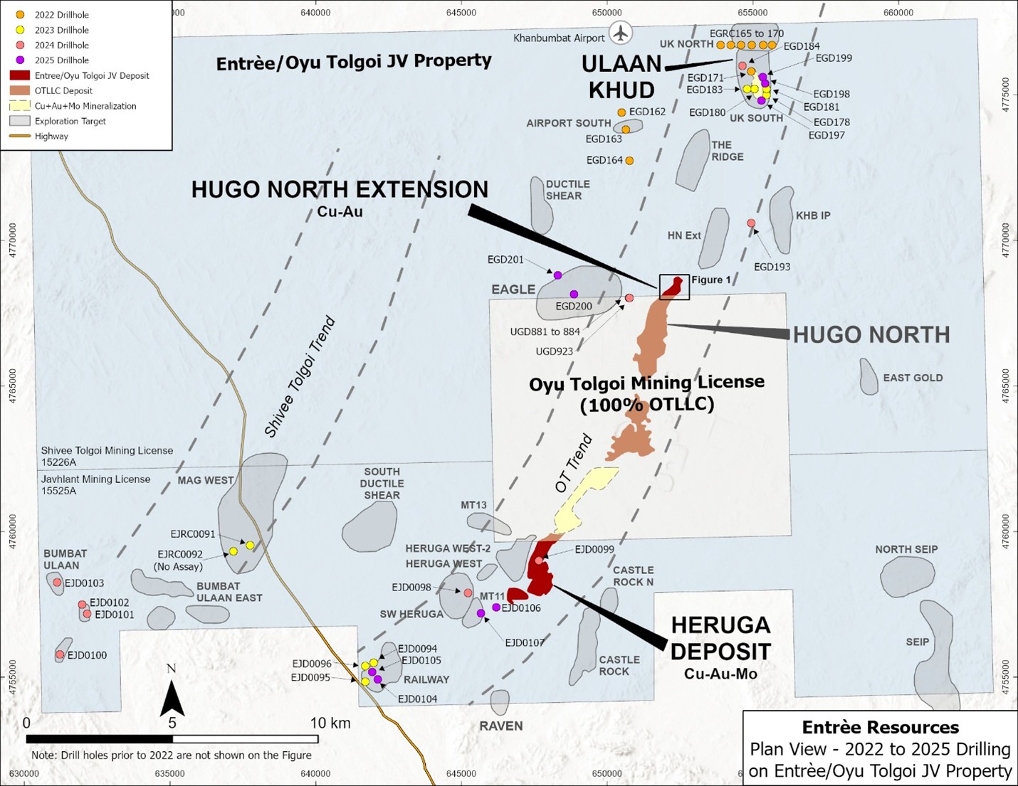
Two diamond drill holes (EGD200 and EGD201) were also completed during 2025 at the Eagle target to test a combined chargeability–magnetic anomaly that coincides with modelled basaltic rocks and a historic molybdenum anomaly. DDH EGD200 intercepted hornfels, part of a contact metamorphic formation over much of the upper part of the drill hole. The hornfels display chlorite-magnetite alteration and disseminated and vein-hosted pyrite-pyrrhotite, magnetite and minor molybdenite. Copper grades over this interval are generally low (<0.1%), with a few narrow, anomalous intervals grading between 0.1% to 0.23% copper. The lower half of the drill hole consists of alternating granodiorite and hornfels breccia. Throughout most of the drill hole molybdenum assays were anomalous (trace to 569 ppm), including a 314 metre higher grade portion between 266 metres and 580 metres that assayed 99 ppm molybdenum, along with low amounts of copper and gold (Table 5).
Drill hole EGD201 intersected granodiorite over much of the drill hole with local hornfels units, but no significant grades were returned.
OT LLC concluded that the chargeability anomaly at the Eagle target was caused by disseminated sulphides in the hornfels and review of the data could not establish additional drill targets. Therefore, no further exploration activity is recommended for the Eagle target.
Drilling at Railway target included 2 holes, EJD0104 and EJD0105 targeting copper-gold intercepts from previous drilling campaigns that are situated within favourable Devonian stratigraphy (augite basalt) overlapping with a high chargeability anomaly. Neither DDH intersected any significant mineralized intervals, even though DDH EJD0104 crossed multiple fault zones with hydrothermal breccias and persistent chlorite-sericite-epidote alteration.
OT LLC concluded that the previously identified copper mineralization of the southern part of the Railway target does not show any depth potential. No further drilling is recommended for the southern part of the Railway target.
Two DDHs were completed at the MT11 target (southwest of the Heruga deposit). The first DDH (EJD0106) targeted a high-chargeability anomaly within Devonian prospective lithology. The second DDH (EJD0107) targeted a historical magnetotelluric anomaly (MT11 target), also within favorable Devonian lithology. Neither DDH intersected any significant mineralization, and the chargeability anomaly remains unexplained. OT LLC recommends further exploration at MT11, targeting deeper mineralization below 1,500 to 2,000 metres depth.
2025 HNE and Regional Drill Hole Information
Collars for the HNE underground drill holes were surveyed using a Leica TS16 instrument and downhole surveys were collected approximately every 30 metres using an EX-Track system. Collars for the HNE and regional surface drill holes were surveyed using either an Emlid Reach RS3 or Trimble GPS R8 GPS system and downhole surveys were collected approximately every 30 metres using an EZ-Track system. The HNE and regional surface drill holes were collared with PQ diameter core (123 mm) and often reduced to HQ (96 mm) core diameter at depth. Underground holes at HNE were collared using HQ diameter and occasionally reduced to NQ (76 mm) at depth.
Drill core from the 5 drill holes reported for HNE and for the 9 regional drill holes were geologically and geotechnically logged at site by OT LLC. All core was saw-cut on site before being bagged and shipped to the laboratory. Samples were either quarter core or half core depending on whether a portion was also used for metallurgical test work or other purposes. Sample lengths generally averaged approximately 2.0 metres and core recovery was recorded as being very good (>95% recovery), except in localized areas of faulting/fracturing.
Core from HNE and the regional drilling was shipped to ALS Laboratory (“ALS”) in Ulaanbaatar, Mongolia, for sample preparation. ALS is independent of OT LLC, Rio Tinto and Entrée. At ALS the samples were crushed to <2mm and pulverized to 75μm, then the pulps were shipped directly by ALS to their laboratory in Perth, Australia for analysis. Samples were analyzed for gold by MS61L (four-acid digestion of 0.25g sample paired with ICP-MS) for samples <1 g/t Au and by ICP21 (30g fire assay with ICP-AES) for samples >1.0g/t Au. MS61L was used to analyse a suite of 12 elements, including copper, silver and molybdenum. Copper values greater than approximately 0.75% were further analysed by OG62 (ore grade copper using a 0.4 g sample and a 4-acid digestion with an ICP finish).
OT LLC follows a rigorous quality assurance/quality control (“QAQC”) program for the sampling programs that includes the regular insertion of standards, blanks and duplicates into the sample stream. The QP is not aware of any drilling, sampling, recovery, or other factors that could materially affect the accuracy or reliability of the data referred to in this disclosure.
Gravity Surveys
Ground gravity surveys were carried out over the central parts of the Shivee Tolgoi and Javkhlant mining licences during July 25, 2025. The Shivee Tolgoi survey comprised 2,419 gravity stations over 200×100 metre and 100×100 metre grids and the Javkhlant survey comprised 2,857 stations over the same grid configurations. Data collection used high-precision differential GPS and a Scintrex CG-5 gravity meter. Both surveys were designed to in-fill areas of historical gravity readings and then to merge the two datasets. See the figures in the Company’s AIF for the areas of the two gravity surveys.
The Shivee Tolgoi gravity survey covers the projected Oyu Tolgoi mineralized corridor to the north and revealed areas of positive Bouger gravity anomalies in the central, northern, and eastern parts of the survey, with values up to +1.97 mGal (and +0.008 mGal/m², for First Vertical Derivative anomalies). OT LLC suggests that these anomalies could indicate shallow, dense subsurface features, such as Late Devonian quartz monzodiorite intrusions or sulfide-rich mineralized zones, potentially related to the Oyu Tolgoi porphyry system. Overall, a strong Bouger gravity anomaly, about 9 km long and up to 1 km wide, aligns with known mineralization at the south end of the survey at HNE and provides potential exploration targets to the north.
The Javkhlant gravity survey covers the Heruga deposit and also the areas to the east and south of the deposit. The survey revealed areas of strong positive Bouger gravity anomalies in the west-central and northern parts of the survey. This includes a large, 3.5 km long and 750 metre wide northeast trending gravity anomaly that is possibly linked to the Heruga deposit. A second, 1.5 km by 1.6 km, strong Bouger anomaly trends to the northwest and is bordered by low gravity zones, possibly indicating a geological feature.
CSAMT Surveys
The exploration program also competed two large CSAMT surveys, one over the central part of the Shivee Tolgoi mining licence, centered on the Oyu Tolgoi mineralized trend to the north of HNE and the other over the central portion of the Javkhlant mining licence in the vicinity of the Heruga deposit. See the figures in the Company’s AIF for the CSAMT survey areas.
CSAMT is an electromagnetic geophysical technique used to map subsurface electrical resistivity by transmitting controlled audio-frequency currents into the ground and measuring the resulting electric and magnetic fields at receiver sites. The surveys were designed to improve the geological understanding of the mineralized structures hosting the Oyu Tolgoi trend of deposits by delineating resistivity contrasts that may be linked to structural, lithological, or alteration features relevant to the mineralization model and to generate new potential exploration targets.
The Shivee Tolgoi CSAMT survey was successful in outlining a broad low resistivity area (~300-500 Ohm-m) coinciding with the Ulaan Khud copper mineralization, however no distinct low-resistivity anomaly was identified.
The Ridge target was previously identified as a discrete Induced Polarization/Resistivity (“IP”) anomaly. Based on the CSAMT survey results and integrated geological interpretation it is interpreted to be part of a broad resistivity anomaly caused by Carboniferous granodiorite, which is less prospective for porphyry mineralization. Therefore, OT LLC considers the Ridge target to be low priority, and no further evaluation is recommended.
The CSAMT survey also identified a low resistivity zone (<200 ohm-m) coinciding with the HNE deposit. The anomaly is interrupted to the north by a fault (the Granodiorite boundary fault) and a Carboniferous volcanic formation to the west and north. Although the northern continuation of HNE remains a target, the CSAMT survey did not result in any significant anomalies in this area.
The KHB IP and Ductile Shear targets were not covered by the CSAMT survey.
The Javkhlant CSAMT survey was successful in outlining the general boundaries of the corridor containing the Heruga mineralization, defined by an area of low resistivity (450-1,000 Ohm-m) and the location of several major faults, such as the Javkhlant fault and the West Boundary fault.
A new potential target has resulted from the CSAMT survey where a low resistivity anomaly (800 to 1,100 Ohm-m) was identified along a deep, northeast trending fault structure, possibly fed by hydrothermal fluid. This anomaly is the area between the south end of the Heruga deposit and the MT11 target, which has seen limited previous drilling. OT LLC plans to conduct further evaluation in this area, including 3D geophysical/geological modelling before potentially drill testing this target.
Another attractive low-resistivity target occurs a few kilometres to the east of the Heruga deposit and to the north-northeast of the Castle Rock North target. The resistivity response is comparable to the resistivity response at the Heruga deposit and is in an area with no previous drilling.
Geological 3D Modelling
Geological 3D modelling has been initiated over both the Shivee Tolgoi and Javkhlant mining licences, focusing on the main target areas and will incorporate drilling, CSAMT and gravity surveys, previous ground magnetic surveys, geochemical sampling datasets and geological and structural datasets. The purpose of this work is to produce visual representations of subsurface geology and structures and to refine targeting. With this, OT LLC can optimize drill hole design with the aim to identify new shallow and/or deep level copper – gold porphyry mineralization. The results of the modelling are expected in Q2 2026.
QUALIFIED PERSON
The scientific and technical information that forms the basis for parts of this news release was reviewed and approved by Robert Cinits (P.Geo.), a Qualified Person (“QP”) as defined by National Instrument 43-101. For further information on the Entrée/Oyu Tolgoi JV Property, see the Company’s Technical Report, titled “Entrée/Oyu Tolgoi Joint Venture Project, Mongolia, NI 43-101 Technical Report”, with an effective date of October 8, 2021, available on the Company’s website at www.EntreeResourcesLtd.com, and on SEDAR+ at www.sedarplus.ca.
ABOUT ENTRÉE RESOURCES LTD.
Entrée Resources Ltd. is a Canadian mining company with a unique carried joint venture interest on a significant portion of one of the world’s largest copper-gold projects – the Oyu Tolgoi project in Mongolia. Entrée has a 20% or 30% carried participating interest in the Entrée/Oyu Tolgoi JV, depending on the depth of mineralization. Royal Gold, Inc. (through its wholly owned Canadian subsidiary International Royalty Corporation) and Rio Tinto are major shareholders of Entrée, beneficially holding approximately 24% and 16% of the shares of the Company, respectively. More information about Entrée can be found at www.EntreeResourcesLtd.com.
FURTHER INFORMATION
David Jan
Investor Relations
Entrée Resources Ltd.
Tel: 604-687-4777 | Toll Free: 1-866-368-7330
E-mail: djan@EntreeResourcesLtd.com
This News Release contains forward-looking information within the meaning of applicable Canadian securities laws with respect to corporate strategies and plans; requirements for additional capital; uses of funds and projected expenditures; arbitration proceedings, including the potential benefits, timing and outcome of arbitration proceedings; the claim filed by Entrée LLC with the Administrative Court of Mongolia and the potential timing and outcome of the hearing; Resolution 120 of the Parliament of Mongolia; the Company’s plans to continue discussions with OT LLC and Rio Tinto regarding a potential conversion of the Entrée/Oyu Tolgoi Joint Venture Agreement; the Company’s efforts to continue discussions with representatives of the Government of Mongolia and Erdenes Oyu Tolgoi LLC regarding the potential for the State to receive 34% of the economic benefit that the Company derives from its 20% contractual interest in the area of the Licences pursuant to applicable laws of Mongolia; the potential timing of the transfer of the Shivee Tolgoi and Javkhlant mining licences to OT LLC and the assessment of transfer taxes thereon; the potential for Entrée to receive the benefits of the OTIA; the expectations set out in the 2020 Oyu Tolgoi Feasibility Study and the 2021 Technical Report on the Company’s interest in the Entrée/Oyu Tolgoi JV Property; timing and status of ramp-up of the Oyu Tolgoi Lift 1 underground mine; the expected timing of development work on the Shivee Tolgoi mining licence and the potential for delay, which may be significant, if the Shivee Tolgoi mining licence cannot be transferred to OT LLC in a timely fashion; the nature of the ongoing relationship and interaction between the Company, OT LLC and Rio Tinto and the Government of Mongolia and Erdenes Oyu Tolgoi LLC with respect to the continued operation and development of the Oyu Tolgoi project, the transfer of the Licences, and State participation in the area of the Licences; the technical studies for Lift 1 Panels 1 and 2, the 2023 Oyu Tolgoi Feasibility Study, the Lift 2 Pre-Feasibility Study, and the updated resource model for Hugo North (including Hugo North Extension) Lifts 1 and 2 and the possible outcomes, content and timing thereof; timing and amount of production from Lift 1 of the Entrée/Oyu Tolgoi JV Property, potential production delays and the impact of any delays on the Company’s cash flows, expected copper, gold and silver grades, liquidity, funding requirements and planning; future commodity prices; the estimation of mineral reserves and resources; projected mining and process recovery rates; estimates of capital and operating costs, mill and concentrator throughput, cash flows and mine life; capital, financing and project development risk; mining dilution; potential actions by the Government of Mongolia with respect to the Shivee Tolgoi and Javkhlant mining licences and Entrée’s interest in the Entrée/Oyu Tolgoi JV Property; potential size of a mineralized zone; potential expansion of mineralization; potential discovery of new mineralized zones; potential metallurgical recoveries and grades; plans for future exploration and/or development programs and budgets; permitting time lines; anticipated business activities; proposed acquisitions and dispositions of assets; and future financial performance.
In certain cases, forward-looking information can be identified by words such as "plans", "expects" or "does not expect", "is expected", "budgeted", "scheduled", "estimates", "forecasts", "intends", "anticipates", or "does not anticipate" or "believes" or variations of such words and phrases or statements that certain actions, events or results "may", "could", "would", "might", "will be taken", "occur" or "be achieved". While the Company has based this forward-looking information on its expectations about future events as at the date that such information was prepared, the information is not a guarantee of Entrée’s future performance and is based on numerous assumptions regarding present and future business strategies; the correct interpretation of agreements, laws and regulations; the commencement and conclusion of arbitration proceedings and Administrative Court claims, including the potential benefits, timing and outcome of arbitration proceedings and Administrative Court claims; the Company’s ability to engage in discussions and negotiations with the Government of Mongolia and Erdenes Oyu Tolgoi LLC and the potential timing and outcome of any such discussions; the future ownership of the Shivee Tolgoi and Javkhlant mining licences; that the Company will continue to have timely access to detailed technical, financial, and operational information about the Entrée/Oyu Tolgoi JV Property, the Oyu Tolgoi project, and government relations to enable the Company to properly assess, act on, and disclose material risks and opportunities as they arise; local and global economic conditions and the environment in which Entrée will operate in the future, including commodity prices, projected grades, projected dilution, anticipated capital and operating costs, including inflationary pressures thereon resulting in cost escalation, and anticipated future production and cash flows; the anticipated location of certain infrastructure and sequence of mining within and across panel boundaries; the continued ramp-up of the Oyu Tolgoi Lift 1 underground mine; the status of Entrée’s relationship and interaction with the Government of Mongolia, Erdenes Oyu Tolgoi LLC, OT LLC, and Rio Tinto; and the Company’s ability to operate sustainably, its community relations, and its social licence to operate.
With respect to the construction and continued development of the Oyu Tolgoi underground mine, important risks, uncertainties and factors which could cause actual results to differ materially from future results expressed or implied by such forward-looking information include, amongst others, an uncertain and unstable global economic and political environment, including China U.S. tensions and the indirect impacts of war in Ukraine and conflict in the Middle East, which could lead to falling commodity prices, trade actions (including increased tariffs, retaliations, and sanctions), and government efforts to exert more control over natural resources or to protect domestic economies by changing contractual, regulatory, or tax measures; the impacts of climate change and the transition to a low-carbon future; the nature of the ongoing relationship and interaction between OT LLC, Rio Tinto, Erdenes Oyu Tolgoi LLC and the Government of Mongolia with respect to the continued operation and development of Oyu Tolgoi; the continuation of undercutting in accordance with the mine plans and designs in the 2023 Oyu Tolgoi Feasibility Study; applicable taxes and royalty rates; the future ownership of the Shivee Tolgoi and Javkhlant mining licences; the amount of any future funding gap to complete the Oyu Tolgoi project and the availability and amount of potential sources of additional funding; the timing and cost of the construction and expansion of mining and processing facilities; inflationary pressures on prices for critical supplies for Oyu Tolgoi resulting in cost escalation; the ability of OT LLC or the Government of Mongolia to deliver a domestic power source for Oyu Tolgoi (or the availability of financing for OT LLC or the Government of Mongolia to construct such a source) within the required contractual timeframe; sources of interim power; OT LLC’s ability to operate sustainably, its community relations, and its social license to operate in Mongolia; the impact of changes in, changes in interpretation to or changes in enforcement of, laws, regulations and government practises in Mongolia; delays, and the costs which would result from delays, in the development of the underground mine; the anticipated location of certain infrastructure and sequence of mining within and across panel boundaries; projected commodity prices and their market demand; and production estimates and the anticipated yearly production of copper, gold and silver at the Oyu Tolgoi underground mine.
Other risks, uncertainties and factors which could cause actual results, performance or achievements of the Company to differ materially from future results, performance or achievements expressed or implied by forward-looking information include, amongst others, unanticipated costs, expenses or liabilities; discrepancies between actual and estimated production, mineral reserves and resources and metallurgical recoveries; the impacts of geopolitics on trade and investment; trade tensions between the world’s major economies; development plans for processing resources; matters relating to proposed exploration or expansion; mining operational and development risks, including geotechnical risks and ground conditions; regulatory restrictions (including environmental regulatory restrictions and liability); risks related to international operations, including legal and political risk in Mongolia; risks related to the potential impact of global or national health concerns; risks associated with changes in the attitudes of governments to foreign investment; risks associated with the conduct of joint ventures, including the ability to access detailed technical, financial and operational information; risks related to the Company’s significant shareholders, and whether they will exercise their rights or act in a manner that is consistent with the best interests of the Company and its other shareholders; inability to upgrade Inferred mineral resources to Indicated or Measured mineral resources; inability to convert mineral resources to mineral reserves; conclusions of economic evaluations; fluctuations in commodity prices and demand; changing foreign exchange rates; the speculative nature of mineral exploration; the global economic climate; dilution; share price volatility; activities, actions or assessments by Rio Tinto or OT LLC and by government stakeholders or authorities including Erdenes Oyu Tolgoi LLC and the Government of Mongolia; the availability of funding on reasonable terms; the impact of changes in interpretation to or changes in enforcement of laws, regulations and government practices, including laws, regulations and government practices with respect to mining, foreign investment, strategic deposits, royalties and taxation; the terms and timing of obtaining necessary environmental and other government approvals, consents and permits; the availability and cost of necessary items such as water, skilled labour, transportation and appropriate smelting and refining arrangements; unanticipated reclamation expenses; changes to assumptions as to the availability of electrical power, and the power rates used in operating cost estimates and financial analyses; changes to assumptions as to salvage values; ability to maintain the social license to operate; accidents, labour disputes and other risks of the mining industry; global climate change; global conflicts; natural disasters; the impacts of civil unrest; breaches of the Company’s policies, standards and procedures, laws or regulations; increasing societal and investor expectations, in particular with regard to environmental, social and governance considerations; the impacts of technological advancements; title disputes; limitations on insurance coverage; competition; loss of key employees; cyber security incidents; misjudgements in the course of preparing forward-looking information; and those factors discussed in the Company’s most recently filed MD&A and in the Company’s Annual Information Form for the financial year ended December 31, 2025, dated March 5, 2026 filed with the Canadian Securities Administrators and available at www.sedarplus.ca. Although the Company has attempted to identify important factors that could cause actual actions, events or results to differ materially from those described in forward-looking information, there may be other factors that cause actions, events or results not to be as anticipated, estimated or intended. There can be no assurance that forward-looking information will prove to be accurate, as actual results and future events could differ materially from those anticipated in such information. Accordingly, readers should not place undue reliance on forward-looking information. The Company is under no obligation to update or alter any forward-looking information except as required under applicable securities laws.
Figures accompanying this announcement are available at:
https://www.globenewswire.com/NewsRoom/AttachmentNg/ed9a51f6-0e94-43d7-a718-ab3c95c34294
https://www.globenewswire.com/NewsRoom/AttachmentNg/716e4565-680a-4220-811d-03d04201a05c

![]()
Figure 1
Plan View of Newly Released Assay Intervals and Locations of 2022-2025 Drill Holes
Figure 2
Plan View of 2022-2025 Regional Drill Holes
Legal Disclaimer:
EIN Presswire provides this news content "as is" without warranty of any kind. We do not accept any responsibility or liability for the accuracy, content, images, videos, licenses, completeness, legality, or reliability of the information contained in this article. If you have any complaints or copyright issues related to this article, kindly contact the author above.
